


Is Martin County in a flood zone? While much of this scenic area in Florida enjoys higher ground, parts of Martin County, Stuart, Hobe Sound, Sewall’s Point, and Port Salerno fall within FEMA-designated flood zones. Knowing your property’s flood risk—and reviewing official Martin County flood zone maps—is essential whether you’re buying a home, running a business, or looking into flood insurance in Florida. In this guide, we break down flood zone types, show you how to access official FEMA and county maps, and explain coverage options for both homeowners and commercial properties. You’ll also find answers to the most common questions about flood insurance in Treasure Coast communities like Port St. Lucie, Vero Beach, Jupiter, and Palm City.
Living in Martin County, Florida, offers plenty of benefits, from waterfront views to a relaxed coastal lifestyle. However, it’s important to be aware of the potential risks if your home or business lies within a FEMA flood zone or Martin County flood hazard area. Understanding Martin County flood zones and having access to local resources can help residents make informed decisions and take necessary precautions.This includes checking the Martin County flood zone map, FEMA flood maps, and St. Lucie County flood zone maps if you’re considering nearby areas like Port St. Lucie or Jensen Beach. In this post, we offer extensive information about Martin County flood zones, flood zone types, flood insurance, and how you can get more details from local organizations.
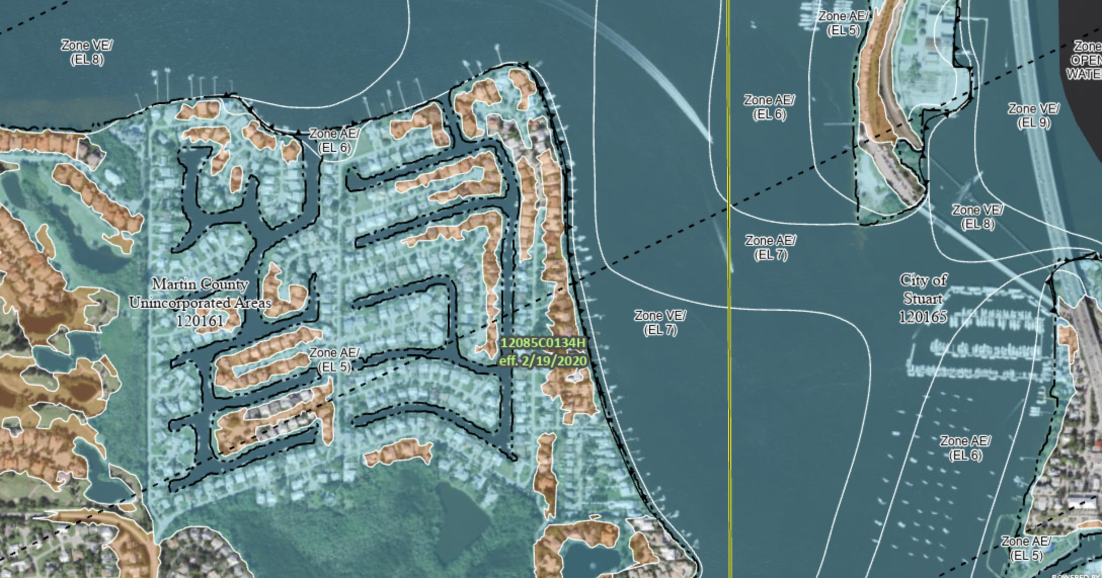
When searching Treasure Coast real estate—whether in Stuart, Palm City, Hobe Sound, or Port St. Lucie—flood zones are a crucial factor to consider for both residential and commercial flood insurance needs. While flooding is not historically an issue in Martin County, it helps to be prepared in the event of an emergency. By learning more about what the different flood zones in Martin County are, you can be ready for any storm and know that you, your family, and your property are safe and protected.This applies whether you’re in a high-risk coastal flood zone near the Indian River Lagoon or a moderate-risk area inland, as identified on FEMA’s National Flood Hazard Layer map.
Types of Flood Zones in Martin County
Martin County employs the Federal Emergency Management Agency's (FEMA) flood zone designations to identify areas prone to flooding. You can view the National Flood Hazard Layer map to enter your address. The flood zones are categorized as follows:
High-Risk & Coastal High-Risk Flood Zones (Special Flood Hazard Areas – SFHAs)
This represents areas at high risk of flooding due to storm surges, heavy rainfall, or nearby water bodies. Property owners within this zone should consider obtaining flood insurance if it is not mandated by their lender. Some zones are also known as Special Flood Hazard Areas (SFHA).
Zone A, Zone AO, Zone AH, Zones A1-A30, Zone AE, Zone A99, Zone AR, Zone AR/AE, Zone AR/AO, Zone AR/A1-A30, Zone AR/A, Zone V, Zone VE, and Zones V1-V30
These zones are clearly marked on the Martin County flood map and FEMA flood zone map. Neighboring coastal communities such as Sewall’s Point and Port Salerno often have large areas designated as VE or AE zones, requiring flood insurance for homeowners and commercial properties.
Moderate Risk Flood Zones
If you are buying Martin County real estate that has this flood zone type, flood insurance is available but usually will not be required by a lender. These areas may be within the area that FEMA believes could experience a flood within 100 to 500 years.
Zone B or Zone X (shaded)
These are shown as shaded areas on FEMA maps and may appear on Indian River County flood zone maps, Palm Beach County flood maps, or Vero Beach flood zone maps depending on your location.
Low Risk Flood Zones
These areas have elevations high enough to be outside of the 0.2% annual-chance-flood, or 500-year flood. Keep in mind that flooding can still occur in these zones due to local drainage issues or intense rainfall.
Zone C or Zone X (unshaded)
While this is a general breakdown of the different flood zones in Martin County, you can always understand your flood zone more through government resources. More information about flood zone categories can be found through FEMA.
Even in low-risk flood zones like Zone C or Zone X (unshaded), property owners in North River Shores, Glen Ridge, or Ocean Breeze may choose optional flood insurance for extra protection.
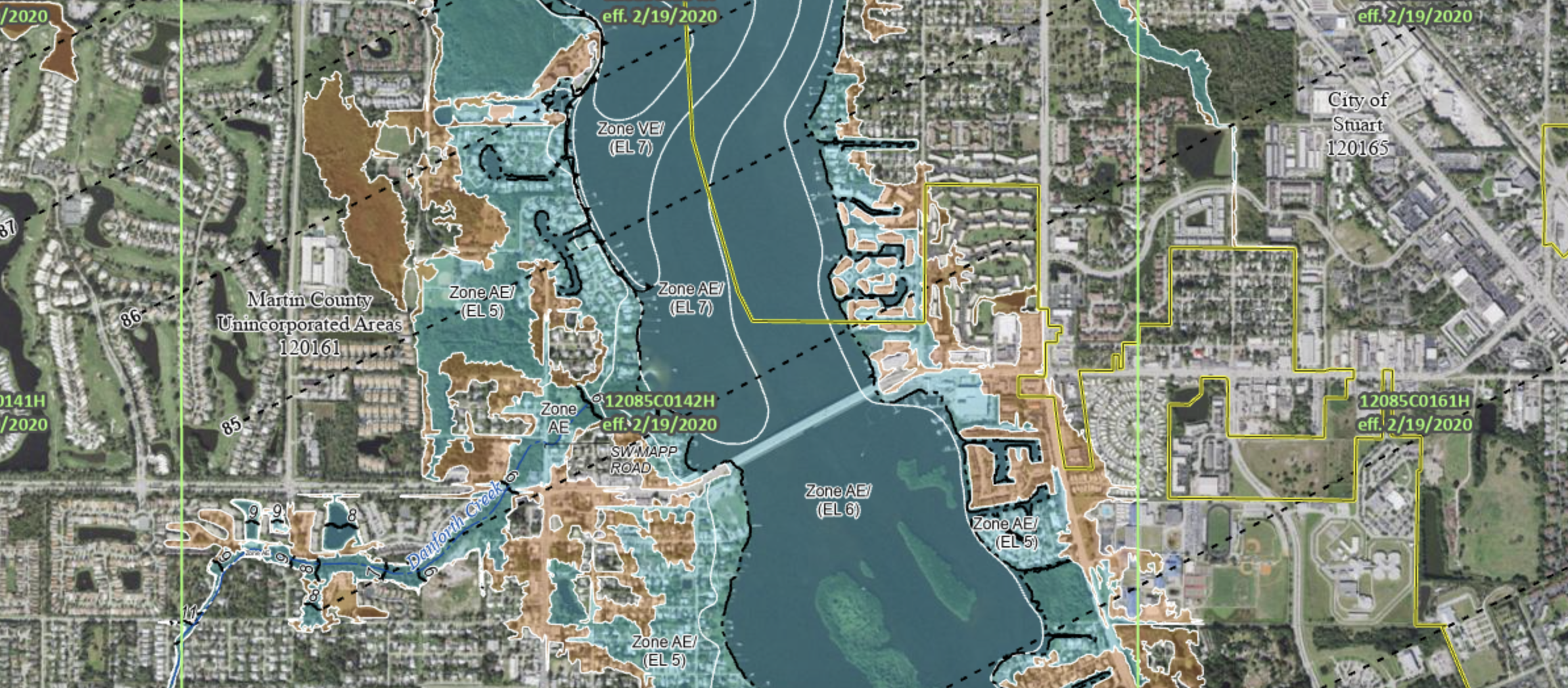
Martin County Flood Zone Resources
Martin County offers a number of helpful resources to assist residents in understand flooding risks and take appropriate measures to mitigate them.
Martin County Emergency Management: The Martin County Emergency Management website provides up-to-date information on emergency preparedness, including flood-related resources, evacuation plans, and alerts.
Flood Zone Information: The Martin County Property Appraiser's Office and Building Department can provide flood zone maps and information on specific properties. These resources help property owners determine their flood risk and make informed decisions.
Local Drainage Management: Martin County's Public Works Department manages and maintains the county's drainage system. They can provide information on local drainage infrastructure, maintenance, and any ongoing projects aimed at mitigating flood risks.
Evacuation Plans: Martin County's Emergency Management website offers evacuation plans and shelter information in case of severe flooding or hurricanes. It's crucial for residents to familiarize themselves with these plans to ensure their safety during emergencies.
You can also view the Martin County FL zoning map and evacuation zones through the county’s official GIS portal. These resources pair well with FEMA flood maps to give you a complete picture of your flood risk.
Flood Insurance in Martin County
Homeowners in Martin County can obtain flood insurance for damage caused by flooding, rising water, storm surges, and heavy rainfall. This includes coverage for residential flood insurance, business flood insurance, and commercial flood insurance in communities like Stuart, Hobe Sound, Tequesta, and Vero Beach South.
In Martin County, flood insurance is typically a separate policy which is not included in your standard homeowner's policy. While premium cost varies, it would help to talk to an insurance professional to see what coverage would look like for your property.
If you have a mortgage on your real estate that is in a flood zone, the lender will usually require a flood insurance policy. The National Flood Insurance Program (NFIP), which is run by FEMA, typically provides flood insurance coverage and is available for Martin County residents. Even if you are not in a high-risk flood zone in Martin County, it may be worth exploring it as an option to provide peace of mind.
For commercial property owners in St. Lucie Village, Port Salerno, or North River Shores, specialized commercial flood insurance policies are available to protect buildings, equipment, and inventory from flood-related losses.
Understanding Martin County flood zones, reviewing FEMA flood maps, and utilizing local resources is crucial for preparation and asset protection. Whether you’re in Stuart, Palm City, Hobe Sound, or Port St. Lucie, knowing your flood risk, maintaining the right insurance coverage, and following official evacuation plans will help safeguard your family, property, and business investments.
Florida Flood Zone FAQs
Yes, parts of North Port are in FEMA-designated flood zones. You can confirm by checking the FEMA flood zone map or the city’s official GIS flood map.
Certain neighborhoods in Port St. Lucie are in AE or X zones, visible on the St. Lucie County flood zone map. High-risk areas typically require flood insurance if you have a mortgage.
Visit the Martin County Property Appraiser’s website or FEMA’s online flood map service. Search by address to see your flood zone designation.
Zone X is generally low-risk, but flood insurance is still recommended for peace of mind, especially in Florida’s hurricane season.
FEMA flood maps provide federal designations for flood risk, while county maps may include local drainage details, zoning overlays, and updated boundary adjustments.